


Lighting a (Metaphorical) Candle Against the Darkness

Shortly after Thanksgiving the song “We Need a little Christmas Now”[1] began to run through my head on constant repeat. It was, quite frankly, annoying.
I don’t know about you, but we felt a little subdued going into the holiday season[2] this year, for reasons external and internal. I did not need Angela Lansbury being exuberant in my head.
We pared down our Christmas decorations to the things that matter to us most: a row of angels on the mantel, lighted stars in the windows, front and back, and a tree that smells wonderful. After a week of trying to get up the oomph to open the box of tree ornaments, My Own True Love declared the tree looked elegant with just lights. I agreed, then dug out the angel that goes on the top so our simple tree looked intentional rather than unfinished.
What we couldn’t pare down were the holiday events we were committed to.Since we couldn’t cancel, we leaned in. To our surprise, we have felt a little better with every gathering. Apparently we did “need a little Christmas right this very minute.”
I hope you, too, have a merry/jolly/happy/blessed time as you celebrate the victory of light over the darkness in the tradition of your choice.
(Just a reminder: If you want to watch the video, click on the post title to take you to your browser.)
PS As I have for the last few years, I’m giving myself a holiday from blogging through the end of the year. I’ll be back in January with some historical stories you probably haven’t heard and some books you might enjoy.
[1] From the musical Mame.
[2] To be honest, I always start the holidays with a bit of Scrooge in my heart.
Word with a Past: Maverick
The word “maverick” has always had overtones of the American West in my head—or at least the American West of a childhood spent watching shows like Gun Smoke, Bonanza, and, of course, Maverick.[1] Imagine my surprise when I recently learned that the word in fact has its roots in nineteenth century Texas.
-

- Bret and Bart Maverick
-
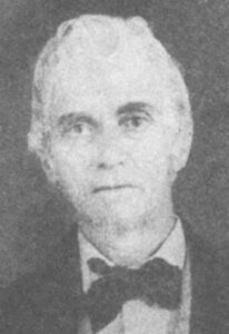
- Samuel Maverick
Samuel A Maverick (1803-70) was born to a wealthy family in South Carolina and earned a law degree from Yale. Instead of taking over one of his father’s businesses, he headed to the Texas region of Mexico in 1835, shortly before the Texas War of Independence began. He joined the Alamo militia—though he did not fight at the Alamo. He signed the Texas Declaration of Independence. He served as the major of San Antonio when the war was over.
Six years after independence, Maverick was captured and imprisoned when Santa Anna sent troops back into Texas, with the intention of re-taking the territory. The Mexicans offered Maverick his freedom if he signed a document saying Texas had been illegally seized and should be returned to Mexico. Maverick refused. When a family friend negotiated his freedom, he again refused to leave until the other prisoners from San Antonio were also released. They all returned home a few days later.
None of which explains how Maverick’s name became a noun, a metaphor, and a cultural construct.
When Maverick arrived in Texas, he bought up huge tracts of land around San Antonio and further east along the Brazos. In 1847, he bought a farm that included some 400 head of longhorn cattle. Maverick was interested in land, not ranching, and he was busy as a member of the new Texas legislature. He left the cattle in charge of a nineteen-year-old enslaved man named Jack, who was quickly overwhelmed by the task. The cattle began roaming unsupervised. Although the original herd carried the brand of the man who had owned them previously, few of the subsequent calves were branded. Neighboring cattlemen knew an opportunity when they saw one. After all, you couldn’t call it rustling if an unbranded steer or two found its way into your herd. Once you branded it, the cattle were yours, right?
In 1856, Maverick sold what remained of his herd to neighboring rancher Augustine Toutant-Beauregard. The terms of the sale specified on-range delivery, which meant the purchaser had to round up the cattle himself. Toutant-Beauregard took advantage of the fact that Maverick (and Jack ) had lost control of the herd. He sent his men into neighboring counties with instructions to round up any unbranded cattle they found, declaring them to be Maverick’s. The term rapidly entered the language to describe unbranded range animals.
By the end of the nineteenth century, the term maverick had come to refer to an individual who goes their own way without reference to the custom, but it didn’t really take off outside Texas until the late 1930s, when Samuel Maverick’s grandson, Maury Maverick, became the Democratic congressman from Texas. He was famously and stubbornly independent in his political positions.—a maverick as well as a Maverick.[2]
Maverick: An unorthodox or independent-minded person.
[1] In fact, I never actually saw Maverick, which went off the air when I was four.
[2] He also coined the term “gobbledygook” to describe “the overinvolved, pompous talk of officialdom.” He said he chose the sounds in the word to imitate the noises made by a turkey.
Before Walt Disney…

A decade before Walt Disney released his first animated short, “Alice’s Day at the Sea” in 1924, illustrator Louis Glackens (1866-1933) created trailblazing animated shorts featuring mermaids, anthropomorphic beasts, and political satire.
His career has often been treated as a footnote to that of his younger brother, Ashcan School artist William J. Glackens.[1] Both Glackens brothers attended the Pennsylvania Academy of Fine Arts, which played an important role in the development of the Ashcan School in particular and modernism in general. Like other members of the Ashcan School, William Glackens painted realistic scenes of everyday life: scenes that according to critic Robert Hughes were “as real as mud, as the clods of horse-shit and snow that froze on Broadway in the winter.” Their paintings were the visual equivalent of muckraking journalism. By contrast, Louis’s work was cartoonish and often fanciful in style. At the same time, his work shared the critical approach to modern life that was central to the Ashcan School.
Louis Glackens began his career as an illustrator and cartoonist working for newspapers in Philadelphia. In 1890, he moved to New York and took a job as as a staff artist for Puck,[2] a satirical weekly magazine based in New York. For the next twenty years, Glackens created hundreds of cartoons and dozens of covers for the magazine, in a variety of formats, styles and targets. He created a series that ran for three years called “In Colonial Days, “that pictured Puritans and Founding Fathers in comical and undignified scenarios and often drew cartoons in which cavemen stood in for their modern counterparts.[3]
When Puck changed ownership in 1915, and subsequently declined in quality, Glackens found work as an animator at Bray Studios, an early animation pioneer credited by historians of animated cartoons as launching animation as a practical form of entertainment rather than a novelty.[4] (My guess is that Glackens found his way to Bray Studios because the studio’s founder, J.R. Bray, worked for a time as a cartoonist at Puck.) Often billed as “The Famous Cartoonist” in the title, he produced more than twenty films for Bray. He is believed to have also worked for the Barré, Pathe, and Sullivan studios, all major players in the early days of animation, though if he did his work there was uncredited. Some of his films, most notably the “Haaden Baad” caveman series, built on the satirical use of historical themes to satirize modern issues that he used at Puck. Others were fanciful fairy tales—predecessors of Disney’s fairy tale-based features.

After five years at Bray, Glackens returned to Philadelphia. He continued to work as a commercial artist, though his work was always a little too bizarre to fit the commercial mainstream. He produced illustrations for book publishers, general interest magazines, newspapers, and for catalogs for his childhood friend, Samuel Sorenson Adams, creator of novelty items such as the Whoopee Cushion and the Dribble Glass He also had paintings in the 1913 Armory show, possibly because his brother William was in charge of selecting paintings for the American portion of the show.
His work as an innovative early animator is largely forgotten. His Whoopee Cushion illustrations live on.

[1] The Ashcan School has been tracking me down for months now. One of these days I’m going to take a day at the library and sink into their work. . Not with a project in mind. Just because they’ve been calling my name. But not right now. I am currently rushing to finish something by the end of the year. Which is coming real soon.
[2] Puck was the first widely distributed humor magazine published in the United States, with a circulation of 85,000 in 1880. The magazine cost 10¢, making it accessible for working men as well as the upper middle class. (The popular Harper’s Illustrated cost 35¢.) Puck used visual humor to ridicule prominent figures and institutions of all kinds: politicians of both parties, union leaders, high society and ethnic minorities. As the character Puck explained in the twenty-fifth anniversary issue, “People get all fussed up when their own ox is gored, but they do love to have me gore the oxen of their neighbors, and on the whole, I please most of the people most of the time.”
[3] The roots of and problems with the pop culture idea of the caveman is too complicated for me to deal with here, but I’m making a note.
[4] And this is where I went down a rabbit hole about Bray Studios, which led me to more rabbit holes about early animation history. A blog post or three on the subject may arrive in coming weeks.